
Massive Earthquake Devastates Mandalay as Myanmar’s Fragile Core Collapses Under 7.7 Magnitude Shock
Myanmar Earthquake Tears Through National Core, Exposing a Fractured State and Fraying Region
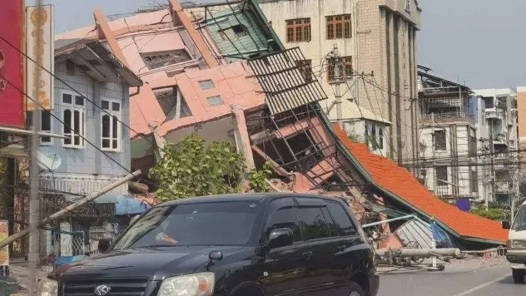
On March 28, the earth tore open beneath Myanmar’s heartland. A massive magnitude 7.7 earthquake, followed closely by a 6.4 aftershock, struck near Mandalay, the country’s second-largest city and a commercial nerve center. Within moments, bridges collapsed, historic palace walls crumbled, and entire communities vanished beneath pulverized homes and liquefied soil. The tremors were not just geological—they fractured the very structure of a nation already teetering under civil conflict and institutional collapse.

The official toll so far — 144 dead, 732 injured — was released hours later by the military-led government. But seismologists and regional analysts were quick to challenge it. One senior analyst noted, “In this kind of urban-epicentral, shallow-focus quake, the early numbers are almost never credible. The real figure could rise into the tens of thousands.” A dire projection from the United States Geological Survey (USGS) estimated potential fatalities in the thousands, depending on the extent of building collapse and secondary disasters like landslides and floods.
Earthquake magnitude quantifies the energy released at its source. While the Richter scale was historically common, the Moment Magnitude scale (Mw) is the modern standard, providing a more accurate measure, particularly for large earthquakes.
This, experts warned, could be one of the most consequential earthquakes of the decade — not just in terms of lives lost, but in the sheer number of systems, power structures, and economies it threatens to bring down with it.
A Catastrophe Long Foretold — And Long Ignored
The quake originated along the Sagaing Fault, a 1,200-kilometer-long right-lateral strike-slip fault that slices Myanmar in two — from the Indian border in the north to the Andaman Sea in the south. Its central segment, known as the Meiktila section, had long been identified as a "seismic gap" — an overdue stretch that hadn't ruptured in nearly two centuries. The last comparable event here was the 1839 Ava Earthquake, estimated at magnitude 8.3.

Did you know that a seismic gap is a segment of an active fault that has remained unusually quiet for a long time compared to other parts of the same fault? These areas are of interest because they might be accumulating stress, potentially leading to a significant earthquake in the future. While seismic gaps are often considered potential sites for future large earthquakes, the reliability of this concept in predicting earthquakes is debated. Despite these uncertainties, understanding seismic gaps helps in assessing earthquake risks and contributes to our knowledge of seismic patterns along fault lines.
In recent years, local geologists warned repeatedly of the fault’s growing tension. In 2023, Myanmar’s own Meteorology and Hydrology Department flagged rising earthquake risks. But those warnings went largely unheeded. Today, that grim prediction has become a reality, and Mandalay, a city of nearly 2 million people, has borne the brunt of the long-awaited rupture.
The main shock, with an estimated rupture length of over 250 kilometers, shook for 70–80 seconds, generating ground accelerations sufficient to collapse both traditional rural structures and urban mid-rises. Compounding the destruction is the city's location on the Irrawaddy River alluvial plain, where soft, saturated soils are prone to liquefaction — a phenomenon that turns solid ground into quicksand.

“Epicenter of the Epicenter”: Mandalay’s Strategic Collapse
Mandalay is not just a city — it is the geopolitical and infrastructural keystone of northern Myanmar. Its bridges connect the nation’s fractured rail and road systems. Its river port links China to the Bay of Bengal. Its population supplies both the army and the resistance with foot soldiers, traders, and civil servants.
The collapse of the Ava Bridge into the Irrawaddy River has effectively severed the country’s north-south transport artery. Communication remains patchy. Only two seismic monitoring stations were active inside Myanmar during the quake — compared to over 200 in Thailand. Emergency assessments now rely on foreign computer models, not local data.
Comparison of Seismic Monitoring Station Density in Myanmar and Neighboring Countries
| Country | Approx. Number of Seismic Stations | Land Area (km²) | Station Density (per 10,000 km²) | Source Note |
|---|---|---|---|---|
| Myanmar | 19 | 676,578 | 0.28 | Data from DMH; earlier reports mentioned 30 stations in collaboration with EOS. |
| Thailand | 71 | 513,120 | 1.38 | Thai Meteorological Department (TMD) network. Earlier data mentioned 40 stations. |
| India | 160 | 3,287,263 | 0.49 | National Center for Seismology (NCS) operates over 160 stations. Planned expansion to 150 mentioned in 2021. |
| China | 2000 | 9,596,961 | 2.08 | Network expanding from ~950 to ~2000 broadband stations. Another source mentions 4511 stations used for a specific model. |
| Indonesia | 411 | 1,904,569 | 2.16 | Indonesian Agency for Meteorology, Climatology and Geophysics (BMKG) operated 411 stations in 2021. |
The Myanmar military government, already under siege from ethnic armed groups and international isolation, now faces a multi-front crisis with inadequate tools and rapidly eroding legitimacy. According to one regional observer, “What we’re seeing is the complete paralysis of a central authority in the face of a catastrophe.”
Power Vacuum or Strategic Opportunity?
For Myanmar’s fragmented opposition — especially the network of ethnic armed groups and local resistance militias — the earthquake presents both tragedy and opportunity.

With government forces logistically paralyzed, areas once under fragile military control may soon shift into the hands of local actors. If they manage to coordinate community-based relief, it could bolster their legitimacy and accelerate de facto decentralization.
But this is not a clean vacuum. Many rebel-held regions are themselves within or adjacent to the quake-affected zones. Losses in lives, leadership, or logistics could also weaken their operations — particularly as the region heads into Myanmar’s devastating five-month monsoon season beginning in May.
“A State with No Rails”: Economic Implosion on the Horizon
The disaster has torn through Myanmar’s already fragile economic core. Roads are impassable. Railway lines are twisted. Ports are submerged or inaccessible. For a country already battered by civil war and economic sanctions, this earthquake may represent a terminal event for the central government’s control over Upper Myanmar.
Myanmar's GDP Growth Trend (2013-2025)
| Year | GDP Growth Rate (%) | Key Event/Period |
|---|---|---|
| 2013 | 8.4 | Peak growth |
| 2014-2019 | ~6.0 (average) | Strong growth period |
| 2020 | Significant decline | Global pandemic impact |
| 2021 | -10.5 | Severe contraction |
| 2022 | 3.5 | Economic recovery begins |
| 2023 | 3.3 | Recovery continues |
| 2024 | 2.5 (Q4) | Current situation |
| 2025 | 2.4 (projected) | Near-term outlook |
Investors with exposure to Myanmar — particularly in infrastructure, commodities, and textiles — are now staring into an abyss. "This is not a correction," one Southeast Asia-focused fund manager said. "This is a collapse. Our risk models never priced in the complete vaporization of Mandalay's transport and labor base."
The impact on neighboring economies is also significant:
- China’s Yunnan province felt strong tremors, with instrumental intensities reaching up to magnitude 6 equivalents. Long-period seismic waves caused noticeable swaying in high-rises.
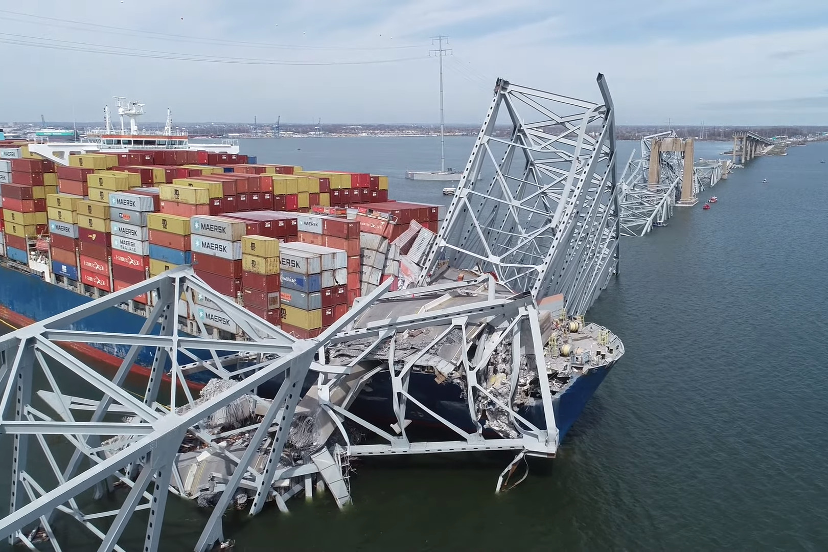
- In Bangkok, the quake prompted the collapse of a partially built office tower, leaving more than 20 workers missing. Engineers suspect not the earthquake's intensity, but the failure of basic structural integrity, exacerbated by non-seismic building designs common in Southeast Asia.

Rescue workers at the site of a collapsed building (france24.com) - Thailand and India have opened emergency aid corridors. ASEAN is mobilizing regional humanitarian support. But geopolitical tensions and Myanmar’s fragmented governance may slow or politicize distribution.
A Humanitarian Window Rapidly Closing
Perhaps the most alarming consequence is temporal. Analysts warn that Myanmar’s rescue and recovery timeline is brutally short: about 40 days before the monsoon turns vast swaths of the country into an inaccessible swamp.
If roads are not hardened and aid routes not secured by then, hundreds of thousands of survivors may be cut off from food, water, and medical care for months. “We’re talking about a scenario where the second wave of deaths — from disease, hunger, and exposure — may eclipse the first,” one humanitarian logistics expert said.
The memory of Cyclone Nargis in 2008, which killed an estimated 138,000 people due to delayed government response, now looms large. The difference: Nargis struck a single delta. This quake has shattered a country’s core.
Did you know that Cyclone Nargis, which struck Myanmar (Burma) in May 2008, is considered one of the deadliest tropical cyclones in recorded history?[1][2] Ranking as the country's worst natural disaster, this Category 4 equivalent storm unleashed winds up to 217 km/h (135 mph) and, most devastatingly, a massive storm surge reaching 3.6 to 7.6 meters (12-25 ft) that penetrated 40-50 km (25-31 miles) inland across the densely populated Irrawaddy Delta. This surge caused catastrophic destruction, contributing to an official death toll of over 138,000 people killed or missing, affecting an estimated 2.4 million lives, rendering over a million homeless, and inflicting over US$10 billion in damage, significantly impacting Myanmar's vital rice production.
Investment Implications: Catastrophic Risk and Reluctant Opportunities
Short-Term: Stay Away
Any capital deployed in or near Myanmar now faces unprecedented risk. Humanitarian considerations aside, the business environment has become uninvestable. Key takeaways for institutional investors:
- Divest or reduce exposure to Myanmar-based production and logistics operations.
- Reassess insurance portfolios for catastrophe-linked assets in Southeast Asia.
- Monitor supply chain nodes, especially those linked to natural resources, garments, and agri-exports from Myanmar.
Mid-Term: Watch Regional Spillovers
- Thailand’s construction and inspection sectors may face a regulatory reckoning.
- China’s Belt and Road interests in Myanmar could face realignment, if not retrenchment.
- Illegal economies — from cyber scams to narcotics — may capitalize on the chaos. Expect a shift in regional criminal logistics, especially along porous borders.
Long-Term: Rebuilding as a Theme
If — and it’s a big if — Myanmar stabilizes politically, the eventual reconstruction effort could be vast. This would require:
- Billions in multilateral aid and foreign construction contracts.
- Establishment of disaster-resilient infrastructure.
- Possible realignment of Myanmar’s economic geography, as some regions become permanently depopulated or unviable.
Such a play, however, is for only the most risk-tolerant, politically connected capital — and not anytime soon.
A Seismic Metaphor Made Real
Myanmar’s earthquake is more than tectonic. It is symbolic — a literal rupture of fault lines long denied and papered over. It has laid bare the fragility of governance, the limits of infrastructure, and the cost of ignoring inevitability.

For global investors, the lesson is not just about Myanmar. It is about understanding that "grey rhinos" — high-probability, high-impact risks — do charge eventually, and when they do, they do not just destroy markets. They redraw maps.
Coined by Michele Wucker, a 'Grey Rhino' in risk management refers to a highly probable, high-impact threat that is obvious yet often neglected. Unlike unforeseen 'Black Swans', these are large, visible risks we should see coming but frequently fail to address adequately before they charge.
As one analyst dryly concluded, “The next time a local researcher warns that a major fault line hasn’t ruptured in 100 years — listen. Then check your portfolio.”